Cavnue is the world’s leading smart road developer.
The future of roads is smart, efficient, and automated.
We deliver digital and physical road infrastructure to enable the safe, efficient, and automated transportation of goods and people.
We are on a mission to give roads a major upgrade. Leveraging AI-driven insights, Cavnue’s roads enhance awareness, deliver proactive guidance, and optimize road capacity and operations. With intelligent infrastructure, we are redefining the future of road performance.

Our projects are bringing this vision to life.
In Michigan
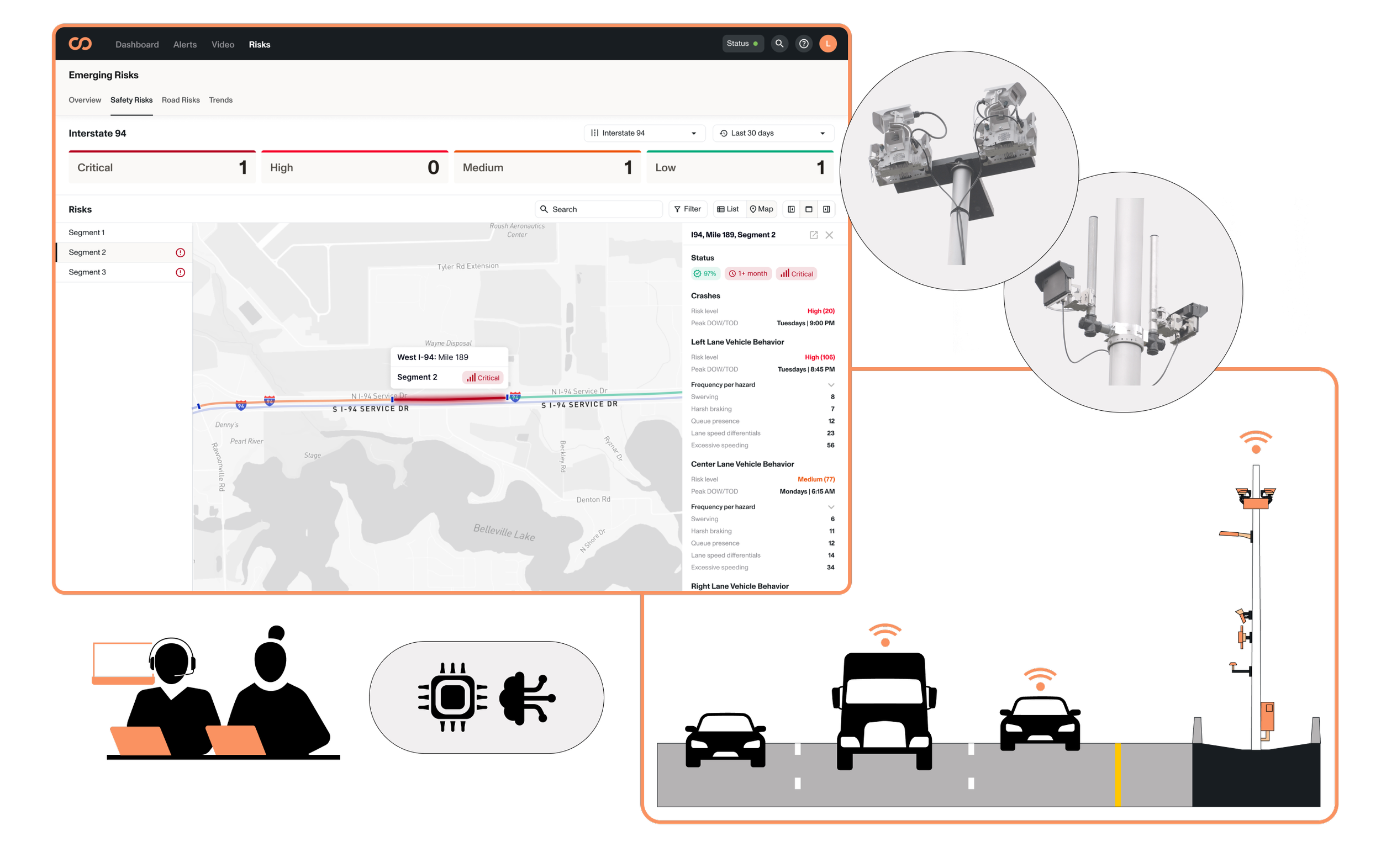
Cavnue, in partnership with the Michigan Department of Transportation, built the world’s first connected and automated vehicle (CAV) corridor on Interstate 94.
The Michigan CAV Corridor, focuses on a 39-mile segment on Intestate 94 from Ann Arbor to Detroit. The initial phase involves a three mile segment serving as a proof of concept. This project aims to enhance safety, alleviate congestion, and support the integration of advanced vehicle technologies. By implementing state-of-the-art infrastructure—including sensors, advanced wireless communications, and a comprehensive digital model of the roadway—the corridor is designed to accommodate personal vehicles, public transit, and freight.


In Texas
Cavnue is collaborating with the Texas Department of Transportation to build the nation's first smart freight corridor on State Highway 130.
The SH 130 Smart Freight Corridor focuses on a 21-mile segment of State Highway 130 in the greater Austin area. This project integrates advanced roadway technologies to provide connected and automated trucks with critical information about upcoming road conditions, optimizing performance and enhancing safety for all road users. By implementing a network of sensors, cameras, and edge computing infrastructure, the corridor aims to improve traffic flow, increase operational efficiency, and accelerate the adoption of connected and automated vehicles in Texas.


In Georgia
Cavnue is partnering with the Georgia Department of Transportation to develop a pioneering smart freight corridor on State Route 307.
Cavnue is partnering with the Georgia Department of Transportation to launch the SR 307 Smart Freight Corridor along a 6-mile stretch of State Route 307, linking the Port of Savannah’s Garden City Terminal to Interstate 16. As one of the nation’s most vital freight gateways, this corridor will serve as an initial deployment to evaluate how smart road technology delivers benefits today and prepares for a more automated future. By delivering real-time visibility into traffic operations and roadway hazards, the project aims to improve safety, efficiency, and reliability for freight operators across Georgia’s logistics network.

As seen in:
-
![FOX Business logo with the words 'The Bottom Line' next to it.]()
Aiming to mitigate traffic, Michigan's smart highway pilot completes construction
-
![The logo of Axios with the text 'Axios' in black letters and a blue stylized 'A'.]()
First look: America's smartest highway
-
![A waterfall flowing over a cliff into a lush river valley surrounded by forested hills under a cloudy sky.]()
Can a ‘Smart Highway’ in Texas Pave the Way to Self-Driving?
-
![TechCrunch logo in black text with a stylized 'T' and 'C' on the left.]()
Sidewalk Infrastructure is looking to build roads specifically for autonomous cars
-
![Fast Company logo in black text on a white background.]()
The best transportation design of 2024
-
![Inc logo]()
How This Smart Road Could Usher in the Future of Autonomous Vehicles
-
![Yahoo Finance logo with purple text and exclamation point]()
Michigan is building the nation’s first smart highway
-
![Logo for Tech Brew with the words 'TECH' in black and 'BREW' in orange.]()
How Cavnue is using a Michigan pilot project to make roadways smarter